

Keywords:
Sampling mangrove peat in the Southern Gulf of California.
Mangrove forests, tropical coastal wetland ecosystems, are severely threatened by human activities,1 on local scales due to development and worldwide by sea level rise.2 They provide many important ecosystem services, including nursery habitat for fishery species,3 protection of coastal communities from storm surge damage,4 timber, and ecotourism.5 Mangroves are highly productive6 and contain more carbon per area than other tropical forests.7 This long-term carbon sequestration is the most important ecosystem service that mangroves provide on the global scale. Mangrove carbon is stored in deep layers of organic-rich sediment, or peat. In some forests, mangrove peat deposits have been found to extend more than 10 m below ground and back in time more than 10,000 years.8 However, little effort has been made to use careful sampling and mapping of mangrove peat to quantify carbon stocks. My research with the Gulf of California Marine Program aims to do so for the mangrove forests of Mexico.
Belowground carbon storage may be spatially variable. Quantifying the amount of carbon in mangrove forests therefore requires some understanding of the geological and ecological processes that control fluxes of carbon into and out of the sediment. Of the many factors that may control carbon storage, I set out to examine two in this study: forest size and location in the forest. I hypothesize that large forests contain more carbon per unit area as they likely have a longer and more stable history of sediment deposition in any given location. I also hypothesize that the waterfront fringe zone will store less carbon per unit area than the landward hinterland zone because hinterland areas usually represent the older parts of the forest where a relatively large amount of sediment build-up has occurred over time. Earlier field work at one of our mangrove study sites supports this idea.9
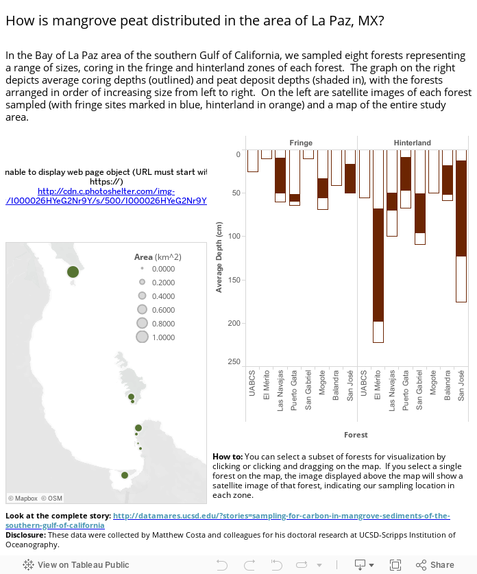
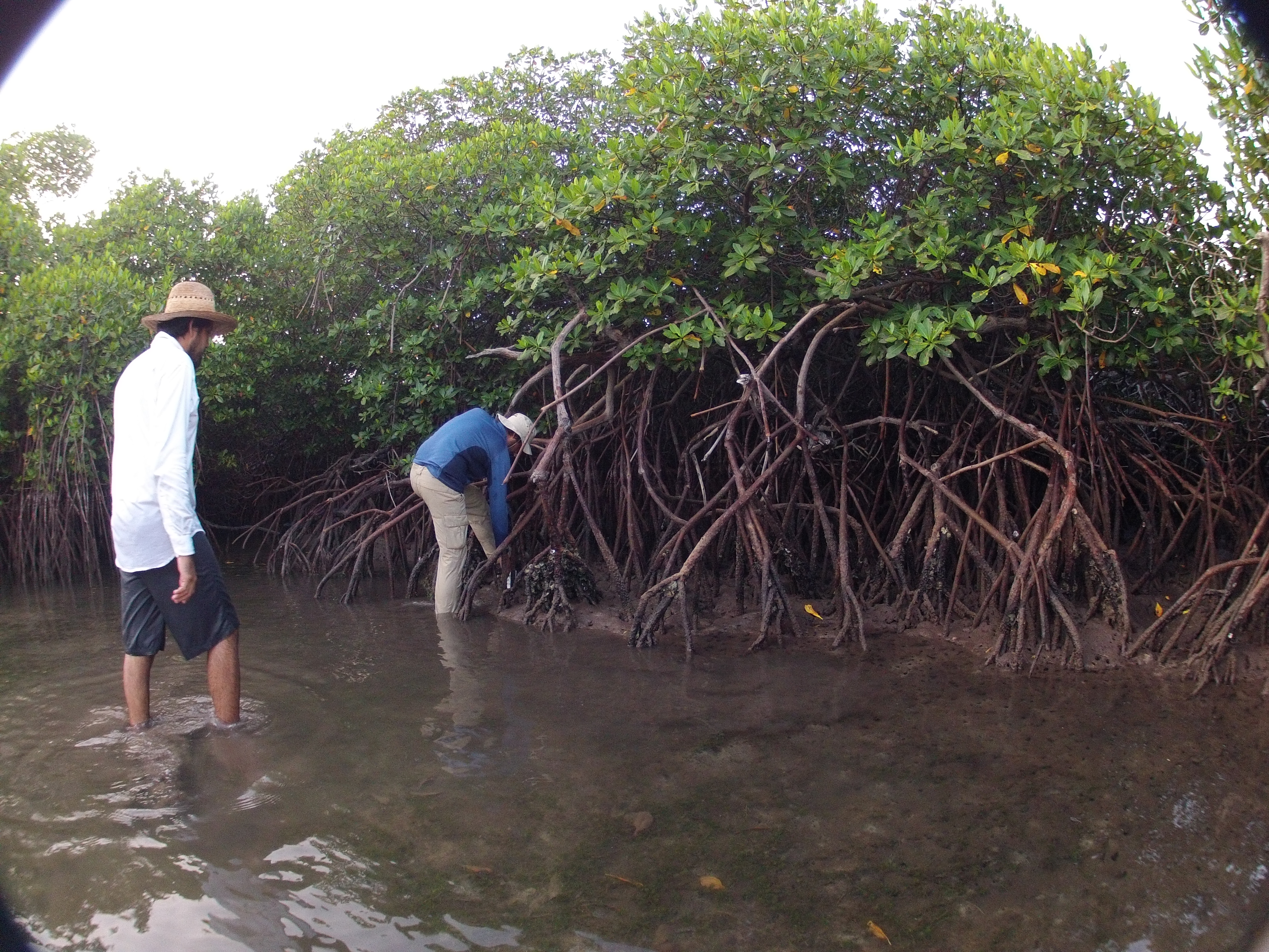
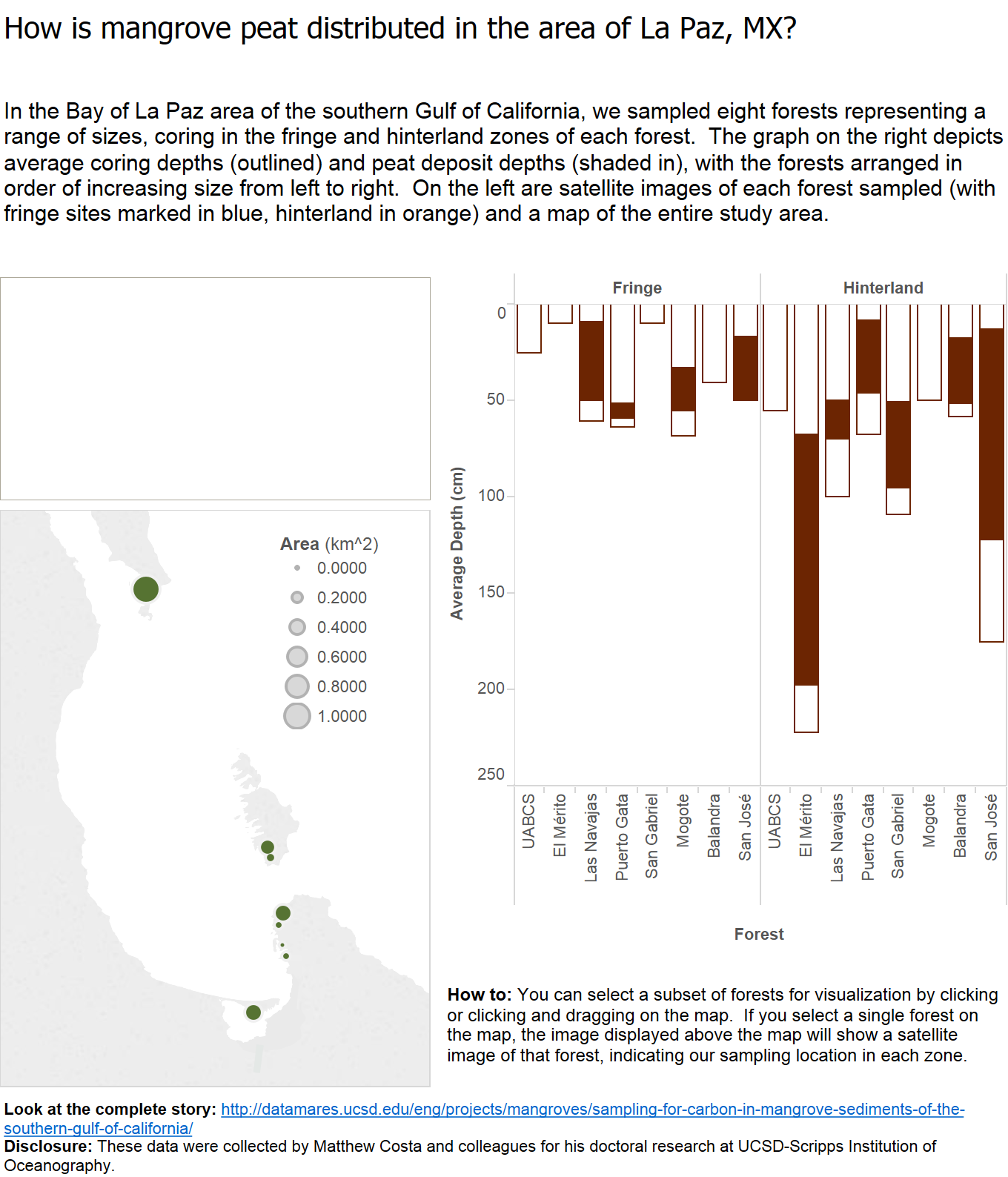
In the summer of 2014, my colleagues and I sampled mangrove sediments in forests near the city of La Paz, BCS, in the southern Gulf of California. We sampled in a range of forests that varied in total area, and, in each forest, we sampled in both fringe and hinterland locations. Though our coring device could reach down to 3 m, the actual depth sampled varies from site to site, because hard material (such as limestone or sand) resisted the corer and thus marked the bottom of each of our core samples.
Conclusions: A glance at the depth distributions of mangrove peat in these forests suggests some hints to the questions that we set out to answer. There appears to be no relationship between carbon storage and forest area; both large and small forests showed thick layers of peat, or no peat at all. It is worth noting that peat distributions were highly variable from forest to forest, with some yielding no peat despite repeated sampling, and others turning up remarkably rich deposits. An interesting pattern begins to emerge in the comparison of zones. Large peat deposits are only found in the hinterland zones, whereas, in fringe zones, the deposits are only a few tens of centimeters thick, or altogether missing. This pattern lends support to the hypothesis that hinterland zones contain more peat than fringe zones and brings into sharper focus our ongoing enquiry into the history of growth and deposition of these forests.
Ongoing Work: In order to understand the history of these forests and their carbon storage in greater detail, more work remains to be done. We are currently analyzing the samples taken from our sample cores to estimate the carbon content of these mangrove sediments. We will use these data to map the forests’ carbon storage. Using x-ray fluorescence, we will examine the history of the sediment deposition in the cores, identifying chemical tracers of past environmental conditions relevant to the storage of carbon. By doing so, we hope to reconstruct how climate, geography, and ecology have formed the foundations of the forests that we see today.
Authors:
Matthew Costa
Contact Information:
DOI:
10.13022/M3Z596
Affiliations:
N/A
Acknowledgements:
Thank you to Dr. Octavio Aburto-Oropeza and Dr. Exequiel Ezcurra for support and guidance, and especially to Paula Ezcurra and Juan José Cota Nieto for tirelessly making this fieldwork possible. The funds for this work were provided by the Packer Foundation, the Scripps Institution of Oceanography Graduate Department, and the Mia Tegner Memorial Fellowship in Coastal Ecology.
How to cite this story:
Matthew Costa (2014): Sampling Mangrove Peat in the Southern Gulf of California. dataMares. InteractiveResource. http://dx.doi.org/10.13022/M3Z596
References
2. Gilman, E., J., et al. 2007. Environ Monit Asses 124: 104–130.
3. Aburto-Oropeza, O. et al. 2008. PNAS 105: 10456–10459.
4. Costanza, R., et al. 2008. Ambio 37: 241–248.
5. Costanza, R., et al. 1997. Nature 387: 253–260.
6. Bouillon, S., et al. 2007. Global Biogeochemical Cycles 22: GB2013.
7. Donato, D. C., et al. 2011. Nature Geoscience 4: 293–297.
8. McKee, K. L., et al. 2007. Global Ecology and Biogeography 16: 545–556.
9. Ezcurra, P., and E. Ezcurra. 2014. pers. comm.
Satellite images © 2014 Digital Globe.