

Keywords:
Spatial Distribution of Potential Fishing Effort in the Gulf of California, Mexico.
The Gulf of California is well known for being one of the world’s top marine biodiversity hotspots (1). The highly productive waters also make it an important economic resource for Mexico, supporting large industrial, artisanal and recreational fishing industries. However, as with many global fisheries, the high production has led to a somewhat overinvestment in fishing, and stocks within the Gulf are heavily fished (2).
Among the consequences of heavy fisheries exploitation is the alteration of the food web. Fisheries have shifted from large, long-lived species belonging to high trophic levels (like top predators), to small short-lived species from lower trophic levels (like those that eat primary producers) (3).
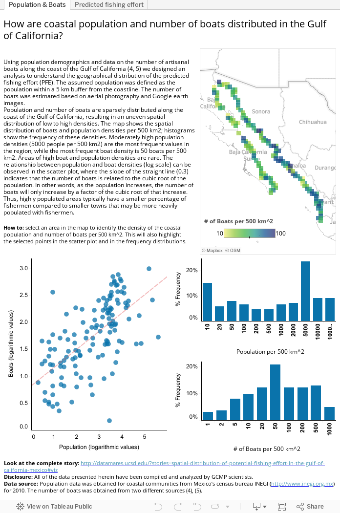
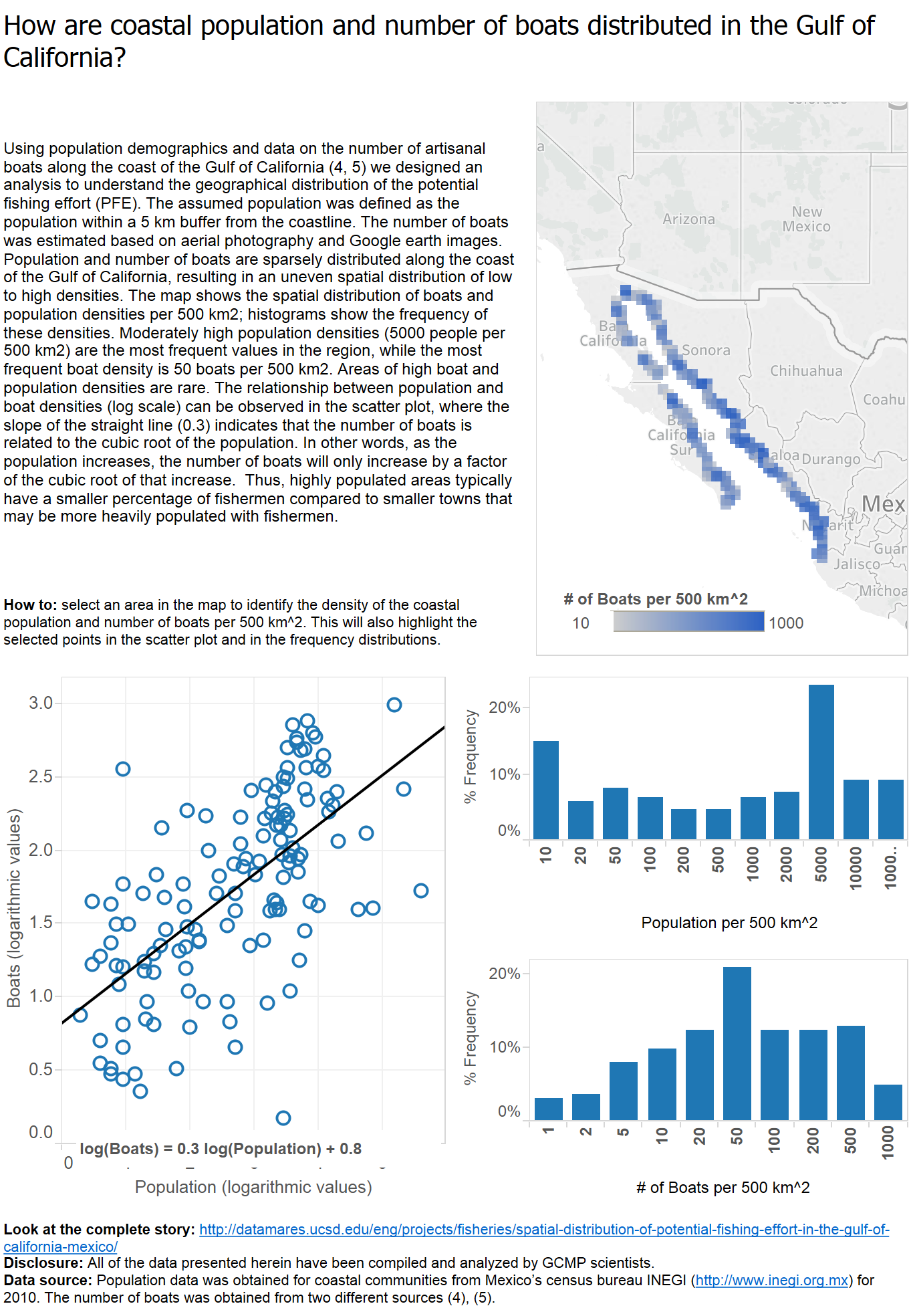
Although Mexican fisheries landings are recorded by CONAPESCA, very little is known about how many fishermen are catching these reported landings. Using human population and fishing vessel density (i.e., population and fishing vessels per unit of area) from years 2006-2007 (4, 5), we were able to predict the spatial distribution of the potential fishing effort (PFE) in the Gulf. Our analysis was restricted to these years due to the limited data available on the number of fishing boats operating in the Gulf.
The objective of this exercise is to use population and small-scale boats (also known as pangas) distribution to calculate the potential fishing effort, which is an index that represents fishing pressure on our coastal and marine resources in the Gulf of California. This index could potentially impact decision-making processes, which ultimately drive the development of sustainable fisheries management frameworks.
Major findings:
Fishing pressure has a significant human impact on coastal and marine systems and is challenging to quantify. Our method is based on empirical data and provides a common and simple way of measuring fishing effort for regional fisheries assessments. By displaying potential fishing effort in a map, we provide a model for estimating fishing intensity and distribution. The uneven distribution of population and boats, show that PFE is also unevenly distributed along the Gulf. However, we can distinguish higher PFE close to high population concentrations (like the coast of Sonora and Sinaloa) or areas with great number of boats (such as the upper Gulf of California).
Mexico has a sustained population growth since 1960 (7), which intensifies the need for accurate measures of fishing pressure and associated effects on coastal ecosystems. With our model researchers can identify areas of high activity that might need management intervention. The method also allows the correlation of the results to other oceanographic parameters and fisheries landings data to understand if fishing effort could surpass what the oceans can produce (6). Ultimately, sustainable fisheries management frameworks have to be able to work in poor-data situations, and this model provides a potential solution.
Authors:
Marcia Moreno-Baez*, Alfredo Girón-Nava**, Octavio Aburto-Oropeza**, Andrew F. Johnson**, Júlia Corominas***, Brad Erisman****, Exequiel Ezcurra*****.
Contact Information:
DOI:
10.13022/M33S3C
Affiliations:
*Centro para la Biodiversidad Marina y la Conservación; ** Scripps Institution of Oceanography, UCSD, California, EUA; *** Independent researcher; ****University of Texas, Texas, EUA; ***** University of California Institute for Mexico and the United States (UC MEXUS).
Acknowledgements:
We thank the foundations that supported our work (Walton Family Foundation, David and Lucile Packard). Also, we thank Mexico’s census bureau INEGI (http://www.inegi.org.mx), World Wildlife Fund (WWF) and T. Plomozo-Lugo for giving access to their data.
How to cite this story:
Marcia Moreno-Baez, Alfredo Girón-Nava, Octavio Aburto-Oropeza, Andrew F. Johnson, Júlia Corominas, Brad Erisman, Exequiel Ezcurra. (2015): Spatial Distribution of Potential Fishing Effort in the Gulf of California, Mexico. DataMares. InteractiveResource. http://dx.doi.org/10.13022/M3001R
References
(2) Cisneros-Mata, M.A., 2010. The importance of fisheries in the Gulf of California and ecosystem-based sustainable co-management for conservation, in: Brusca, R. (Ed.), The Gulf of California, biodiversity and conservation. Arizona-Sonora Desert Museum Studies in Natural History. University of Arizona Press, Tucson, Arizona.
(3) E. Sala, O. Aburto-Oropeza, M. Reza, and L. G. López-Lemus, “Fishing down coastal food webs in the Gulf of California,” Fisheries Management, pp. 1–7, Jan. 2004.
(4) T. Plomozo-Lugo, “Propuesta para la regionalización ribereña en el Golfo de California,” Universidad Autónoma de Baja California Sur, 2010.
(5) J.A. Rodríguez-Valencia, M. López-Camacho, D. Crespo y M.A. Cisneros-Mata. 2008. Tamaño y distribución espacial de las flotas pesqueras ribereñas del Golfo de California en el año 2006. Volumen I: Resultados y Discusión. 21 p. Available at: http://awsassets.panda.org/downloads/rep_tamanio_distribucion_flotas_pesqueras_080710.pdf
(6) W. Swartz, E. Sala, S. Tracey, R. Watson, and D. Pauly, “The Spatial Expansion and Ecological Footprint of Fisheries (1950 to Present),” PLoS ONE, vol. 5, no. 12, p. e15143, Dec. 2010.
(7) Banco Mundial: Crecimiento de la población (% anual): Indicadores del desarrollo mundial. Available at : http://datos.bancomundial.org/indicador/SP.POP.GROW. Data policies available at : http://web.worldbank.org/WBSITE/EXTERNAL/BANCOMUNDIAL/0,,contentMDK:22640962~pagePK:1131638~piPK:437370~theSitePK:263688,00.html